
Tropical storm warnings for Hispaniola and Texas as hurricane center watches 5 systems in Atlantic and Gulf
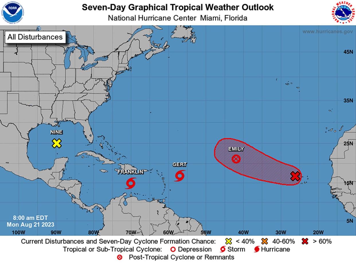
The National Hurricane Center on Monday is monitoring a total of five tropical systems in the Atlantic Ocean and Gulf of Mexico.
One of those systems, Tropical Storm Franklin, will veer north toward Hispaniola, and has prompted tropical storm warnings for the southern coast of Haiti and the Dominican Republic. The National Hurricane Center also warned of potential flooding there, and in Puerto Rico. Once Franklin is back over water, the system by Friday could become the second Atlantic hurricane of the season.
The system heading west in the Gulf of Mexico has led to tropical storm warnings for the southern coast of Texas.
None of these systems is currently projected to head to Florida. The fifth system is off the coast of Africa, and is expected to form into a tropical depression in the coming days.
Tropical Storm Franklin
As of 2 p.m. Eastern time Monday, Tropical Storm Franklin was located about 275 miles south of Santo Domingo, Dominican Republic, with maximum sustained winds at 50 mph. Though it’s currently moving west at 4 mph, the NHC forecasts it to arc sharply north over Haiti, making landfall Tuesday night, and not heading toward Florida.
Tropical storm warnings were issued for the southern coasts of both Haiti and the Dominican Republic, with expected storm surge of 1 to 3 feet. There is a tropical storm watch in effect for the north coast of the Dominican Republic and areas of the Turks and Caicos Islands.
Franklin will likely hit Haiti and the Dominican Republic as a tropical storm, but could become a hurricane after it moves northeast past the island and out to sea, according to hurricane center estimates.
The system could bring 5 to 10 inches of rain to Haiti and the Dominican Republic and 2 to 6 inches to Puerto Rico, according to the latest estimates. The NHC warned of potential flash and urban flooding.
As the system moves back over water it could strengthen into a hurricane by Friday, when it will be headed in a northerly direction, toward the waters east of Bermuda.
Tropical Storm Gert
Gert formed early Monday, hours after two other tropical storms — Franklin and Emily formed Sunday.
As of 2 p.m. Monday, Gert was located about 410 miles east-southeast of the Caribbean, moving west at 7 mph and maximum sustained winds at 40 mph, just 1 mph above the minimum top winds for tropical storm formation.
Gert’s tropical-storm-force winds extend out up to 70 miles from its center. Forecasters, however, expect Gert to be short-lived. The latest outlook indicates Gert may become a remnant low Monday and dissipate by Tuesday.
Strong upper-level winds and interference from Tropical Storm Franklin to its west should disrupt organization. The system could dissipate at any time.
Remnant Emily
The NHC downgraded Emily to a post-tropical cyclone in its 11 a.m. update.
The system is expected to turn northward in the coming days. It may encounter some favorable conditions for regeneration, but the NHC thinks reformation is unlikely.
Gulf system
The NHC issued tropical storm warnings for the Texas coast on Monday for the disturbance that made for a rainy weekend in South Florida. The warnings extend from the Mexico border north through Corpus Christi to Port O’Connor. Watches extend to nearly Freeport, south of Houston.
The system is on its way to the western Gulf of Mexico coastline and is expected to be a tropical storm or tropical depression before Tuesday. The storm, located about 480 miles east of Port Mansfield, Texas, has an 90% chance at developing within the next two days, and it expected to make landfall Tuesday morning. Coastal flooding is possible Monday night through Tuesday morning.
The NHC also warned of inland flooding and flash flooding in the mountainous terrain of Mexico, in watersheds that flow into the Rio Grande River on the U.S.-Mexico border.
The next named storm to form would be Harold.
African coastal system
The disturbance close to Africa’s west coast could become a tropical depression later this week as it moves west-northwest across the eastern tropical Atlantic.
As of 11 a.m. Monday, it was given a 40% chance of developing within 48 hours and 70% within seven days.
“At this time we’re not seeing any signs that any of these are going to be able to make it all the way to us,” National Weather Service meteorologist George Rizzuto said Sunday.
Monday will be a drier day in South Florida with chances of showers and storms but “much less coverage” than the past few days, Rizzuto said.
Temperatures will likely reach just below the criteria for a heat advisory.
The National Hurricane Center has been predicting an “above-normal” 2023 hurricane season as a result of ongoing record-breaking sea surface temperatures that continue to fight off the tempering effects of El Niño.
While sea surface temperatures have remained hot for longer than anticipated, El Niño’s effects, which typically reduce hurricane chances, have emerged more slowly.
The NHC, which operates under the National Oceanic Atmospheric Administration, has forecast 14 to 21 named storms, including 6 to 11 hurricanes, and two to five major hurricanes.

