
How I spent 16 months journeying from the top to the bottom of England in a canal boat
My home is a floating island on more than 2,000 miles of interconnected inland waterways in England and Wales. In my 17-metre narrowboat home, I have travelled from the most northerly of the joined waterways – within sight of the Lake District – to the most southerly, about 30 miles from the Channel.
It took me 16 months to complete but I was never in a hurry, travelling as slowly as the seasons change. Along the way, between Tewitfield in Lancashire and Godalming in Surrey, I enjoyed some meandering diversions, based on talk I had heard along the towpath, to waterways that seemed too good to miss: the River Weaver, the Ashby canal, the upper Thames. This meant that by the time I reached Godalming, the distance had swollen from the most direct 387 miles to 517 miles, with 220 locks.
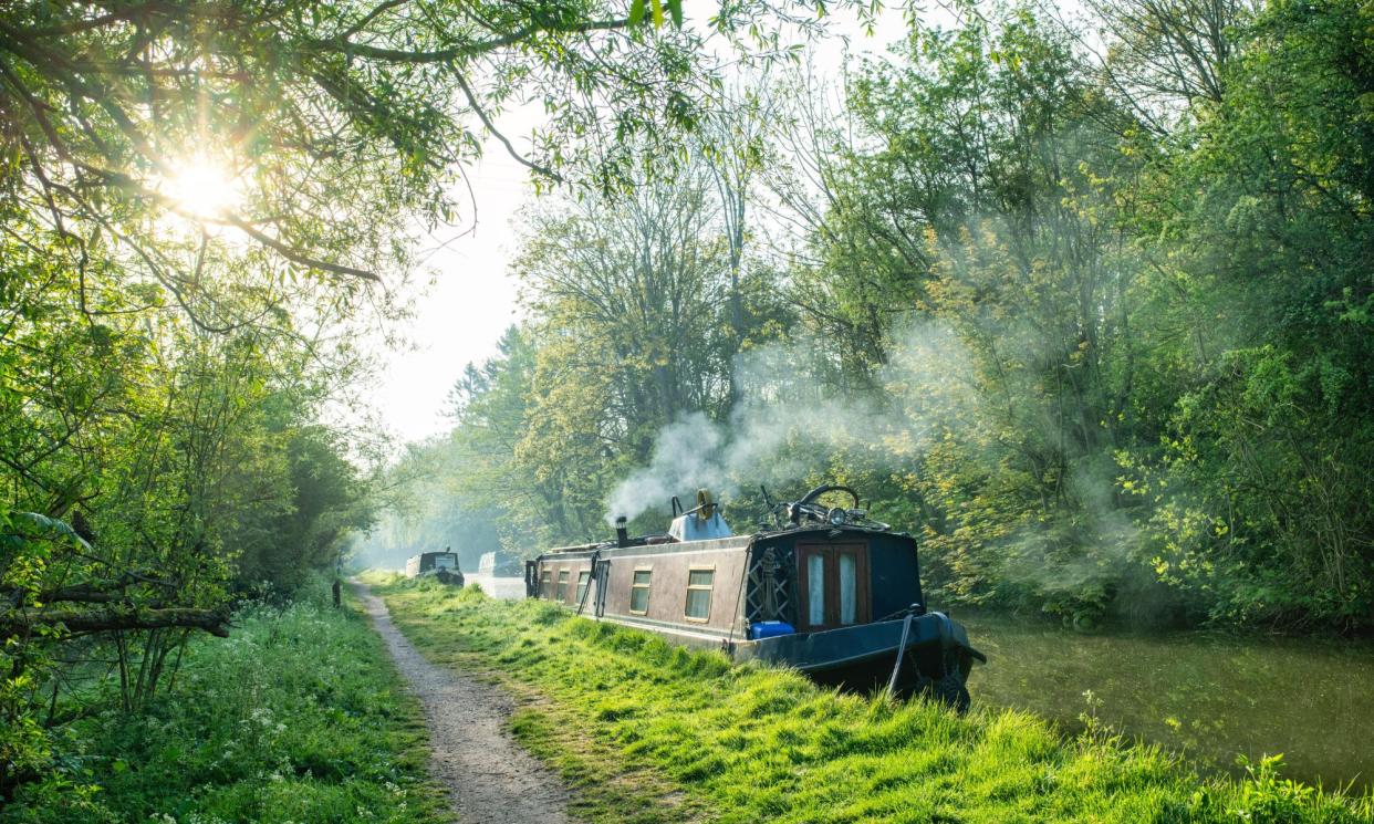
On the waterways, a journey progresses as if you’ve passed through a portal to a former century and now move at a very different speed from that at which the rest of life is lived, on a route edged with wildflowers even within sight and sound of roads and railway tracks.
In Wigan, the canal has sunk, and so has the surrounding land. Hollows – called flashes – have filled with water and are now full of birds and yachts. Reed-edged pools of light glitter either side of the canal, which has been raised up on an embankment. The canal has become deeper as its sides have been raised higher. My boat is like a model on a catwalk, cruising through the lakes below.
On the waterways, a journey progresses as if you’ve passed through a portal to a former century and move at a very different speed from that at which the rest of life is lived
The subsidence is due to millions of tonnes of coal having been extracted at Ince Moss colliery. Mining began in 1863 and continued until the late 1960s. Up to a million tonnes of coal a year was dug up in that time. No wonder the earth sank.
During the Great Depression, George Orwell visited this stretch of canal to research his book The Road to Wigan Pier. I borrowed a copy from Wigan’s smart new library. “I remember a winter afternoon in the dreadful environs of Wigan. All round was the lunar landscape of slag-heaps and … the factory chimneys sending out plumes of smoke. The canal path was a mixture of cinders and frozen mud, crisscrossed by the imprints of innumerable clogs, and all round … stretched the ‘flashes’ – pools of stagnant water that has seeped into the hollows caused by the subsidence of ancient pits. It was horribly cold. The flashes were covered with ice the colour of raw umber, the bargemen were muffled to the eyes in sacks, the lock gates wore beards of ice. It seemed a world from which vegetation had been banished; nothing existed except smoke, shale, ice, mud, ashes and foul water.”
Less than 100 years later, this area is famed for water fowl rather than foul water. Birch and willow edge the lakes. The towpath is no longer mud and cinders but smooth concrete. Instead of factory workers clopping in clogs, there are cyclists, dog walkers and birdwatchers with binoculars and cameras.
I detoured on to the River Weaver in Cheshire, descending 15 metres from the Trent & Mersey canal in the world’s oldest working boat lift. Beyond the chemical works – there because of abundant salt deposits – the Weaver is a serene and languorous river or, more accurately, “navigation”. Its levels are controlled and its route has been altered. I cruised past steep wooded banks dotted with ramsons, bluebells and towering oaks.
On a train or in a car, it would all be a blur. By boat the scenery unfurled at 3mph and sometimes I stayed for days in one place
As I was heading upriver, through Dutton Locks, Mac the lock-keeper saw me through the enormous lock chamber that once took ships 60 metres long. Eighteen narrowboats can fit in the lock at once, said Mac. We rose smoothly, half a million gallons of water filling the lock chamber evenly thanks to the “Stoney’s patented cylindrical equilibrium sluices” installed in the 19th century during a programme of improvements and enlargements when the locks on the Weaver became the biggest in the country.
Mac operated the sluices with the push of a button. More buttons opened the large gates and we cruised on past reeds where great crested grebes and moorhens hide, past sailing swans and schoolboys rowing blindly towards us from a rowing club by Acton Bridge.
Thanks to the ingenuity of 250-year-old engineering, our inland waterways traverse up and down hills. After ascending the Anderton boat lift, I cruised up “Heartbreak Hill”, so named for its many locks (31), and burrowed under a spur of the Pennines through Harecastle tunnel, into the potteries of Staffordshire, stopping to tour the new Wedgwood factory.
One evening I moored near the River Trent, under beech trees with sunlight playing through the leaves and a million river flies dancing above the dark canal.
Days and miles stretched and yawned as county borders were crossed. The geology changed from millstone grit to sandstone to limestone, as did the vernacular architecture. Landscapes changed from moorland to farmland, from urban to rural. On a train or in a car, it would all be a blur. By boat the scenery unfurled at 3mph and sometimes I stayed for days in one place.
Near Braunston, fields adjacent to the Oxford canal appeared like the wind-blown sea. These stationary waves of sheep-grazed pasture predate the canal by centuries. They are the remains of medieval ridge-and- furrow farming. Braunston is a busy canal junction, the site of the 1923 “battle of the canals” when about 50 striking boatmen and their families blockaded the waterway with their boats in protest at wage cuts foisted on them by a cargo company feeling the pinch from railway competition and a surge of wartime vehicles returning to the roads. Heavies were employed to evict the boating families from their boats. Blood was shed. In the end the boaters won, but the demise of cargo carrying proved inexorable.
I puttered through acres of ripening wheat with barely anyone in sight. The summit of the South Oxford canal is one of the twistiest sections in the country. You travel 11 miles to go five. The 18th-century engineer James Brindley’s approach to canal cutting was to minimise the amount of digging and lock making by following the contours of the land, twisting and turning. Later, the need for speed, such as it was, at 3mph, encouraged the surveyors to plan more direct routes, with cuttings and more locks.
In Banbury I watched an otter hunting for crayfish in the canal. A few miles south, the canal soundtrack was of toads chirping and the explosive call of cetti’s warblers
HS2 encroaches on this otherwise quiet and lonely stretch of farmland through which the canal wiggles. For miles around, heavy trucks and dinosaur-like machines heap former agricultural soil into embankments. A new bridge for the 225mph trains is being constructed across the canal. The contrast between speed and slowness will be exaggerated by the otherwise timeless setting.
In Banbury I watched an otter hunting for crayfish in the canal. Close to the pretty village of Lower Heyford, a few miles south, the canal soundtrack was of toads chirping and the explosive call of cetti’s warblers from the hedgerow. Kingfishers and herons were almost daily sightings. I swam in the Cherwell adjacent to the canal.
Then it was on to the Thames at Oxford, where rowers sculled and men wearing straw boaters brayed from their punts. Riverside gardens had boathouses big enough to house a family of four.
At Weybridge I joined the Wey navigation, the start of the last 20 miles of my journey the length of England’s waterways.
“You’ll love Godalming: it’s beautiful!” said one narrowboat dweller above Catteshall Lock, the 16th and last lock on the Wey navigation. “Moor just up there and you’ll hear owls and see deer,” she added, pointing ahead to an overgrown bank next to a coppery meadow.
I turned the boat around at the limit of navigation: the remains of Godalming wharf. This place was once busy with boats and men unloading barrels of gunpowder destined for Portsmouth and the Napoleonic wars – wars that kept the inland waterways busy with trade as merchants feared sending goods by sea.
Here I was, finally at the southernmost limit of the joined waterways. For now, that is. Maybe one day the Wey & Arun canal, abandoned in 1871, will be restored all the way to the south coast. Today it is just a short dead-end arm, a left turn off the Wey navigation after Guildford.
As with the Lancaster canal in the north, a band of dedicated volunteers is campaigning to reopen “London’s lost route to the sea”. Perhaps one day the joined navigable inland waterways of England will stretch from Kendal in Cumbria to Littlehampton in Sussex and narrowboats will be able to cruise from the Lakeland Hills all the way to the Channel. But for now, I had arrived at my long, slow journey’s end.

