
Thunderstorms set to hit Britain as warm spell continues

Thunderstorms are set to hit Britain on Wednesday and Thursday, but warm weather is likely to continue for the rest of the week.
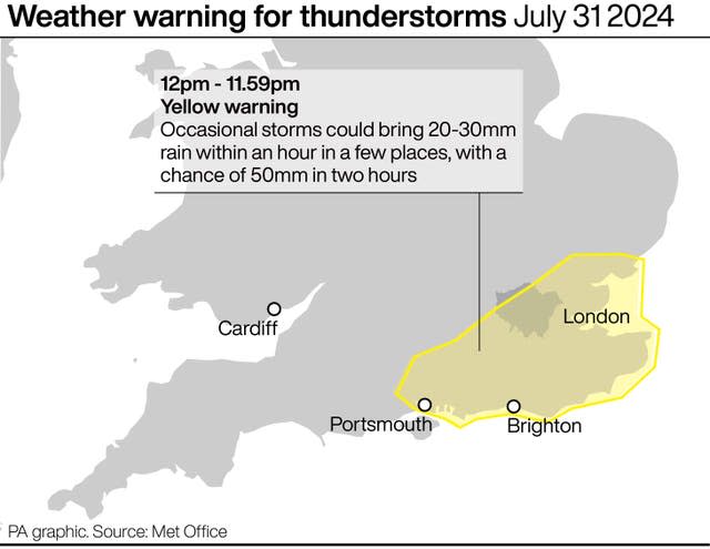
Some areas could see as much as a month’s rainfall in a few hours on Thursday which could cause flooding, the Met Office warned.
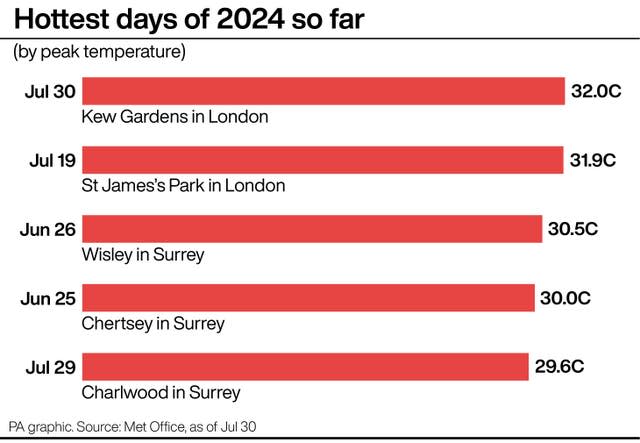
The news comes after Tuesday was provisionally the warmest day of the year so far with a temperature of 32C recorded at Kew Gardens and Heathrow.
Temperatures will remain at 30C or above into Wednesday and Thursday, with thunderstorms expected in the South East on Wednesday and across much of England on Thursday.
Meteorologist at the Met Office, Becky Mitchell, said: “The heat and humidity we’ve got across England and Wales is going to spark off some thundery showers on Wednesday and Thursday so we’ve got some yellow weather warnings in force.”
There is a risk of flooding on Thursday afternoon in some parts of the country, but the thunderstorms will be “quite hit and miss”.
The Met Office said Thursday afternoon could see 50 to 100mm of rain in a few hours in some spots, which is more than a month’s worth of rainfall.
The heat is not set to last into next weekend as temperatures are expected to return to the mid-20s in the south as a band of rain moves through the country on Saturday.
To cope with warm evenings, the Met Office has urged Britons to keep their homes as cool as possible.
Official advice said: “Overnight temperatures are going to be very high so it’s quite hard to cool houses down in that situation because you don’t have the relief overnight and temperatures dropping.
“If you can open your windows at night, try to let some of the cooler air in and keep curtains or blinds shut during the day”.

