
Walks with a focal point: five of the best UK hikes with extras
Even the best walk needs a focal point, an extra something that makes the whole day come alive. For me the swim is the default choice. I’ll jump in that river, lake or sea at any time of year, but there are many other, less bracing, options. These five walks bring a range of highlights.
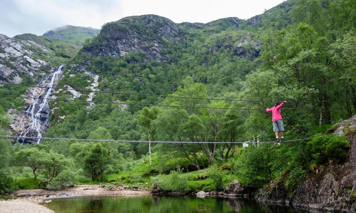
Wobbly bridge, Glen Nevis gorge, the Highlands
In the shadow of Ben Nevis lies this wonderful gorge walk – you can even watch the long lines of people trudging up that magnificent mountain. Park at the end of the road and continue up the narrow wooded valley with glimpses of thundering cascades. Daring folk may like to clamber down and take a rather scary dip – be warned that the crystal clear water is always icy, perfect for the trout that dart through patches of sun. Never get in without seeing where to get out.
Eventually, the path opens out into a broad valley flanked by mountains and continues towards a towering waterfall with great views towards the Ben Nevis massif. To access the foot of the falls, you must cross the Water of Nevis river, which can be done higher up, or via a wobbly wire bridge which is not for vertigo sufferers.
There are plenty of extensions to this walk: continue up the valley or take the path up behind the waterfall and loop south through the Mamores hills – this is the classic Ring of Steall loop, which takes in four Munro peaks (only for experienced hillwalkers) and some intense scrambling on ridges, then returns to the car park after 10 miles.
Distance 3 miles.
Refreshments The Wildcat in Fort William is 100% vegan, the Kilted Camel is not.
Accommodation Burnside Lodge is a riverside cabin with sauna. From £628 for three nights, sleeps four.
Wild swim, Blackchurch Rock, north Devon
When it comes to country walks, I always think loops are overrated. A cliff hike like this one, for example, looks very different in opposite directions. This route could, however, be one-way if you use the bus service between Clovelly and Hartland. Start at Clovelly and head west along the South-West Coast Path. This section, sheltered from the gales by the wild headland of Hartland, is as soft and luscious as a strawberry cream tea. Views north are magnificent and include the Isle of Lundy, once haunt of pirates.
The siren call of cream tea might tempt you back to Clovelly afterwards, but if you fancy a real yomp, keep going
Blackchurch Rock is an impressive triangular lump of naked geology with a large hole in the middle. In good weather at high tide, this is a swim; at low tide it’s a scramble through, then up to the summit. Either one requires good fitness and agility. This swim appears in Wild Swimming Walks: Exmoor and North Devon by Sophie Pierce and Matt Newbury.
The siren call of cream tea might tempt you back to Clovelly afterwards, but if you fancy a real yomp, keep going. The verdant cliffs stretch all the way to Hartland, where you turn south and things get a bit more savage. At the Hartland Quay Hotel turn east and walk the lane into Hartland village, where there is a bus stop.
Distance Clovelly-Blackchurch and back, about 3.8 miles; Clovelly-Hartland via Hartland Point, 13 miles.
Refreshments Cottage Tea Rooms, Clovelly or The Point Kiosk at Hartland.
Accommodation The Landmark Trust’s Bridge Cottage is a thatched house close to a secluded beach, from £360 for four nights, sleeps three.
The Eden Project, Cornwall
This is more like an extra with a hike since the magnificent rainforest and mediterranean domes of the Eden Project, are always going to make up a fairly substantial portion of the day. Walk here, however, and you get a free guidebook and the satisfaction of knowing you have contributed to its sustainability ethos. There are many options, but I started in Penwithick, crossing Carbis Moor and what were once the ravaged wastelands that inspired Tim Smit’s incredible vision of regeneration and hope.
There are cacao pods and coffee beans on the trees in the rainforest dome, olives and oranges in the Mediterranean
St Austell once produced vast quantities of china clay or kaolin, mostly for use in paint and medicines, all exported from the wonderful little harbour at Charlestown. The technique for extracting the precious substance was to dig pits and blast with water: the spoil was piled in huge heaps, hence the local nickname for the area, the Cornish Alps. The pits and heaps are now doing a good job of regenerating themselves and it’s fascinating to see how various species are gaining ground: rhododendrons and heather blooming across the worst acidic barrens, while birch, alder and oak gain a foothold elsewhere. A footpath winds across the area, rising to a fine view of the sea then dropping towards the Eden Project domes, emerging in one of the extensive car parks.
Now approaching its 25th year, the various biomes of the Project are well established: there are cacao pods and coffee beans on the trees in the spectacular rainforest dome, olives and oranges in the Mediterranean. These obvious honeypots are wonderful, but don’t miss out on the external walks and the new microworlds biome, called the Core. To continue the walk down to the coast (with an optional swim in the sea), head south through St Blazey Gate to meet the coastal path at Carlyon Bay, then turn west to the Georgian harbour at Charlestown.
Distance 2.3 miles from Penwithick to Eden; 5 miles from Eden to Charlestown.
Refreshments cafes at the Eden Project.
Accommodation The Pier House, Charlestown, has rooms with views of the old harbour from £150.
Sea Cave, Flamborough Head, East Yorkshire
In the days when London’s demand for coal encouraged any old tub skipper to chance his arm on the sea journey from Hartlepool to the Thames, the dazzling 160-metre chalk headland of Flamborough was a nightmare. It became, for many years, the shipwreck capital of the planet.
Start this walk at North Landing and, as you descend the steep path to the shingle, look out to the northern corner of the bay and spot the remains of one wreck – the naval support ship SS Rosa, which sank here in 1930. This bay was once the haunt of smugglers and their best-kept secret was Robin Lythe’s Cave.
Find the entrance (at low tide) on the rock wall of the south side of the bay. It’s rather inconspicuous, but leads through to a massive cavern that goes down to the sea. Retrace your steps to the cliff top and go around the headland to the lighthouse. From here, either return to North Landing or press on around to South Landing and the mouth of Dane’s Dyke.
The beach here is covered in hagstones, weird eroded lozenges of chalk pierced by holes. Turn inland and head up the dyke, a major iron age earthwork that’s now a wildflower and bird haven. If you want refreshments and don’t mind roadwalking, return via the village. Personally, I prefer to go back along the cliff.
Distance 10 miles for the full circuit.
Refreshments Scrumdiddlyumptious in Flamborough village or the Caravel Bar and North Landing Cafe .
Accommodation The Beverley Arms is a restored coaching inn in the market square of this attractive town an hour from Flamborough. Doubles from £125.
Medieval art, St Mary’s Church, Kempley, Gloucestershire
Robert Frost’s “The road not taken” poem is an old favourite of many, and this walk takes the paths that Frost regularly trod with his fellow poet Edward Thomas (and for whom that particular verse was written) in the years leading up to the first world war.
The two “extras” are the churches, the first of which, St Mary’s, holds some of the best-preserved medieval wall paintings in Europe. Park in the lane, walk by the handsome pink exterior walls and through the wooden porch and there they are, astonishingly well preserved.
On my visit I find an elderly gentleman on a bench in the churchyard who has come, after 70 years, to see the paintings again
Built in the early 12th century, the nave has the more earthly visions of the medieval artists, while the chancel gets the heavenly scenes of salvation and Christ at the Apocalypse. When such murals became unpopular, they were whitewashed over, and only rediscovered in 1872. Victorian conservation methods, however, backfired. The lacquer that was used to “preserve” the delicate paintings turned black with age and hid them for a second time.
On my visit I find an elderly gentleman on a bench in the churchyard who has come, after 70 years, to see them again. “In the 1950s they had just been rediscovered,” he tells me, “and only a small area had been uncovered, so I’ve come to see them properly.”
The path is part of the 100-mile circular Three Choirs Way, which connects the cathedrals of Gloucester, Worcester and Hereford. Head south through fields to a lane after nearly a mile. There you turn right and head into Kempley for the second church, St Edward’s. Normally, I avoid any church built after Victoria took to her throne, but this is different. Influenced by the Edwardian Arts and Crafts movement, it has lots of fine features including a “jam tart” window.
Follow the road to a T-junction, then turn right and continue until you cross Kempley Brook (not really a swimming option). Here join another long distance path, The Daffodil Way, (best time of year for this is March/April) and head north back to St Mary’s.
Distance 3.2 miles.
Refreshments none on the route.
Accommodation Three Choirs Vineyard has doubles from £120.

