
Storm Lilian map shows where UK weather warning in place
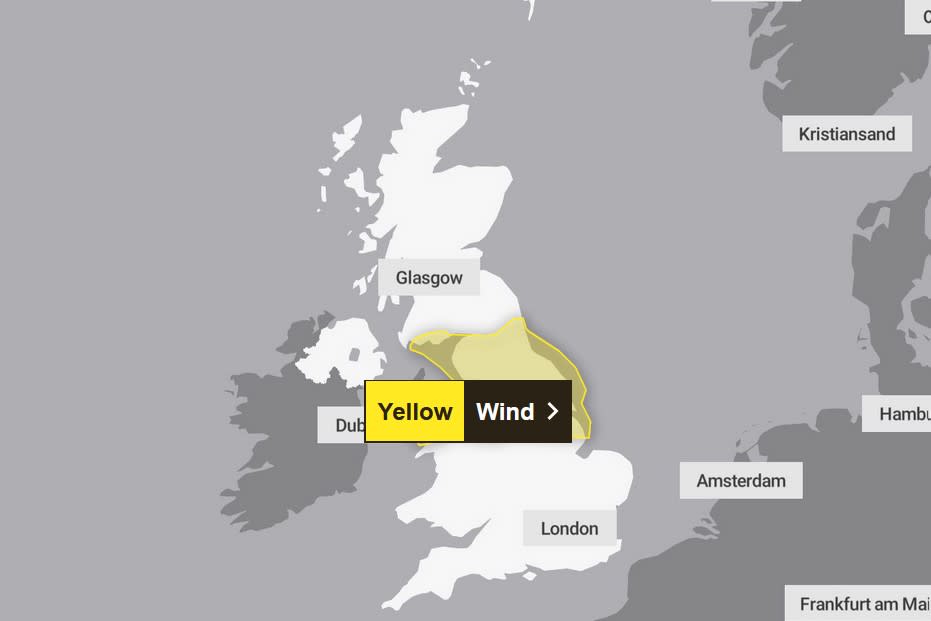
Storm Lilian is surging through northern parts of Wales and England.
Gusts of up to 80mph are expected, with travel disruption, flooding, power cuts and dangerous conditions near coastal areas all likely.
A yellow wind warning covering northern England and northern Wales is in force until 11am on Friday, with the storm widely expected to bring gusts of 50 to 60mph.
It caused three miles of congestion on the M6 near Knutsford, Cheshire, early on Friday after a tree fell on the carriageway. All lanes had reopened by 9am.


And the impact of the severe weather had already been felt outside the expected regions on Friday morning, with National Highways warning the M48 Severn Bridge in Gloucestershire had been closed in both directions between junctions 1 and 2 due to the strong winds.
However, Lilian’s influence is expected to “wane” by Friday afternoon as it reduces in intensity and pushes off into the North Sea. Only scattered showers are expected for most of the rest of the day, the Met Office said.
#StormLilian has been named and is forecast to bring strong winds and heavy rain to parts of the UK tonight and on Friday morning
Stay #weatherawarepic.twitter.com/o7CazOHWQE— Met Office (@metoffice) August 22, 2024
After the possibility of some heavy showers early on Saturday, settled conditions are likely to develop across southern and eastern England and Wales with sunny spells and dry conditions mixed with the odd chance of scattered showers.
Temperatures will reach highs of 21C on Saturday and Sunday and 23C on Monday in the South East, slightly below average for the time of year.
Read more: 'Lucky escape' during Storm Lilian as uprooted tree narrowly misses driver on his way to work (Birmingham Live)
Here, Yahoo News UK breaks down what the weather will be like for each region of the UK over the coming days.
London and the South-East
Friday
Will start very windy with rain clearing as dry and bright conditions develop. Maximum temperature 23C.
Saturday to Monday
Rain on Saturday morning clearing to sunny spells. Some heavy showers possible. Largely dry and bright on Sunday and Monday. Feeling cool.
South-West
Friday
Blustery winds and rain clearing to leave a day of sunny spells. Maximum temperature 21C.
Saturday to Monday
A breezy bank holiday weekend with some bright and sunny spells mixed with possible heavy showers on Saturday. Temperatures slightly below average.
Midlands
Friday
In the East Midlands, staying windy with some isolated showers mixed with dry spells. Maximum temperature 21C. In the West Midlands, more sunny spells. Maximum temperature 21C.
Saturday to Monday
Sunny with some heavy showers on Saturday in the East Midlands. Bright but showery on Sunday. More wind and cloud on bank holiday Monday.
A breezy weekend in the West Midlands with occasionally heavy showers on Saturday. Dry and cloudy on bank holiday Monday.
North-East
Friday
Windy with bright conditions and some isolated showers. Maximum temperature 20C.
Saturday to Monday
Sunny with heavy showers on Saturday. Bright spells on Sunday with wind and rain arriving on Monday. Feeling cool.
North-West
Friday
Heavy rain and strong winds will ease to leave sunny spells. Maximum temperature 19C.
Saturday to Monday
Breezy through Saturday and Sunday with sunny spells and some heavy showers. Cloudier with more persistent rain on bank holiday Monday.
Scotland
Friday
Heavy rain with some sunny spells. Maximum temperature 18C.
Saturday to Monday
Sunny with showers over the weekend. A dry start on Monday before outbreaks of rain.
What can we expect for the Bank Holiday Weekend?
Find out more with Annie 👇 pic.twitter.com/mvyt46DBY0— Met Office (@metoffice) August 21, 2024
Northern Ireland
Friday
Bright and sunny with some heavy showers possible. Maximum temperature 17C.
Saturday to Monday
Sunny with showers over the weekend. A dry start on bank holiday Monday but rain will arrive in the afternoon.
Wales
Friday
Sunny spells with strong winds. Maximum temperature 19C.
Saturday to Monday
A breezy weekend with scattered showers and sunny spells. Cloudier with more rain possible on bank holiday Monday. Feeling cool.

