
What UK weather will be like near you over bank holiday weekend
As millions prepare getaways for the August bank holiday weekend, some will need to pack either sun cream or umbrellas – depending on what part of the country they are heading to.
While plenty of dry and fine weather is predicted for some parts of the UK during the bank holiday weekend, other areas will be hit by heavy rain and blustery showers, the Met Office said.
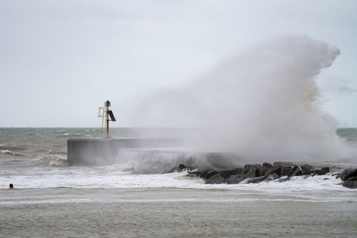
A yellow weather warning for rain is in place across much of South-east England from 6am to 1pm on Saturday.
The warning stretches from the Isle of Wight up to Ipswich in Suffolk and includes London. The Met Office says people in the area should expect “spells of rain, heavy at times, likely to cause some travel disruption and perhaps flooding in a few places”.
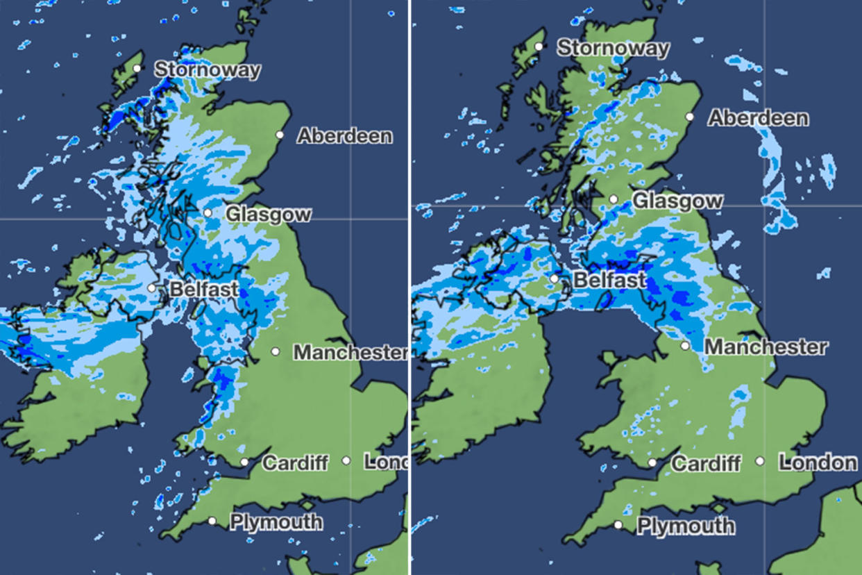
On Sunday, the north of the country is predicted to be hit with more showers and again for the north-west on Monday.
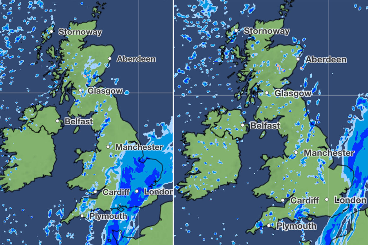
Weather maps show how rain will fall on much of the country at some point – but further south, it will be drier over the course of the weekend.
⚠️ Yellow weather warning issued ⚠️
Rain across parts of South East England
Saturday 0600 – 1300
Latest info 👉 https://t.co/QwDLMfRBfs
Stay #WeatherAware⚠️ pic.twitter.com/gDWiDlT50b— Met Office (@metoffice) August 23, 2024
Met Office deputy chief meteorologist Nick Silkstone said: “Early Saturday will likely see heavy rainfall across southern and south-eastern parts of England, but his should clear by mid-afternoon, with just a few showers following. Thereafter through to Monday, many southern and eastern areas will remain dry and fine, but temperatures will be at or even a touch below average.”
It will be a different story for north-western areas, however, which will see a continuation of the recent unsettled and wet weather. Silkstone added: “Following a wet August so-far for the area, the north-west of the UK will continue to see periods of frequent showers, rain and strong winds.”
Read more: Drivers warned over busiest August bank holiday getaway in years (Gloucestershire Live)
Will there be a heatwave next week?
The bank holiday weekend may be a story of storms and a mixed weather picture, but the outlook for the last few days of August are looking very different.
Current predictions from the middle of next week are for settled conditions with a chance of a prolonged period of hot weather – particularly in the south and south-east.
The Met Office long-range forecast is suggesting drier than average conditions from Wednesday, leading into the start of September.
While the forecaster is hesitant to confidently state what the temperatures will be next week, BBC weather predictions suggest that temperatures of up to 26C will be felt in London and the south east for most of next week.
The Met Office defines a heatwave as a period of at least three consecutive days where the daily maximum temperatures meet or exceed the heatwave temperature threshold. This figure varies by county and so while it may be hot in certain parts of the country for several days, it still may not fall into what is defined as a heatwave.
Yahoo breaks down what the Met Office has said the weather will be like for each region of the UK over the bank holiday weekend.
London and the South-East
A cloudy Saturday morning with heavy and persistent rain. Rain giving way to heavy showers into the afternoon and early evening. Largely dry and bright on Sunday and chance of showers on Monday.
South-West
A breezy bank holiday weekend with some bright and sunny spells mixed with possible heavy showers on Saturday. Temperatures slightly below average.
East Midlands
A cloudy start on Saturday with heavy and persistent rain giving way to heavy showers by late morning. Largely dry in the evening. Increasingly windy and cloudy Sunday. Fine and dry Monday.
West Midlands
Rather cloudy Saturday morning with showers, heavy at times, and longer periods of rain in the far south. Cool and breezy throughout the bank holiday weekend with sunnier spells poking through.
Yorkshire
Heavy showers developing over western hills through Saturday morning. Increasingly windy and cloudy Sunday, with outbreaks of rain or showers. Breezy and partly cloudy Monday, with isolated showers.
North-East
Bright and breezy start on Saturday with heavy showers developing over western hills through the morning, these slowly spreading east, clearing later in the day. Increasingly windy and cloudy Sunday, with spells of rain turning into showers. Breezy and partly cloudy Monday, with showers.
North-West
Cloudy to begin on Saturday but sunnier spells developing into the afternoon. Scattered showers around during the day may be heavy at times. Cool and breezy throughout the bank holiday weekend. Outbreaks of rain on Sunday; cloudy but drier on Monday.
Scotland
Sunny with showers over the weekend. A dry start on Monday before outbreaks of rain.
Northern Ireland
Sunny with showers over the weekend. Rain on Sunday, drier and brighter late evening. Mostly dry on Monday before another spell of rain arrives later.
Wales
A breezy weekend with scattered showers and sunny spells. Cloudier with more rain possible on bank holiday Monday. Feeling cool.
East of England
A cloudy Saturday with heavy and persistent rain giving way to heavy showers into the afternoon. Sunday will have dry weather in the outlook, with light to moderate breezes. A chance of showers Monday.

