
Weather Permitting: Cape Fear Region has some heavy rainfall on the horizon
Heat continues to hold the Cape Fear region in its sultry grasp, but another round of potentially heavy showers is on the way.
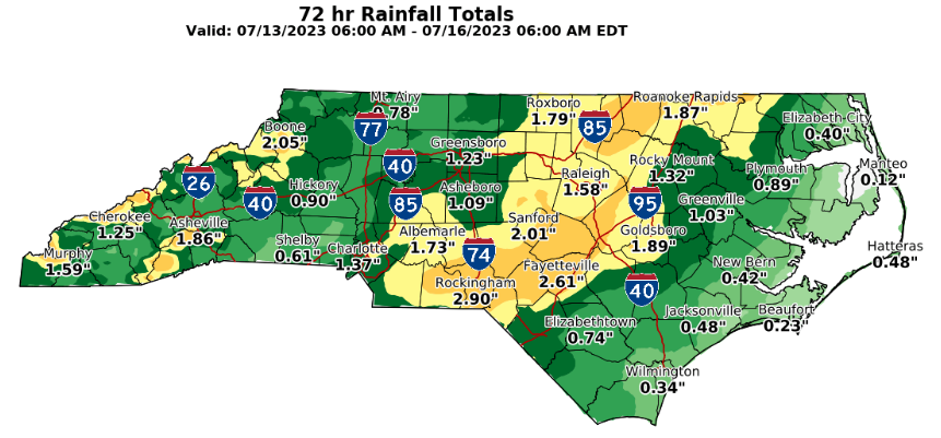
Fayetteville has had a few days to dry out from last weekend's soaking with temperatures climbing to expected mid-summer levels. This weekend will see a return of rain for many in the area. Meanwhile, in the tropics, there are signs of stirring.
Here's the setup
Fayetteville and 95-degree days go hand-in-hand in July, In fact, from mid-June through August, there are only three dates when Fayetteville has never seen triple digits. So this heat is nothing unusual.
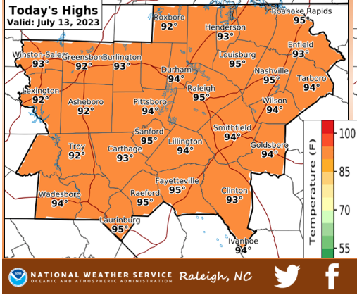
Look for it to continue into the weekend as high pressure continues to hold over the region. We'll see highs of about 95 today, with things getting a bit cooler on Friday as clouds begin to build.
These clouds are a combination of increased moisture (dew points moving toward the mid-70s) and an approaching trough. The trough boundary may trigger evening showers to our north and west overnight, with some lingering clouds floating through Friday morning. If so, the highs will be a bit lower.
Either way, the chance of showers will increase Friday afternoon and evening across the region. Modeling suggests the front will stall over central North Carolina on Friday, triggering slow-moving showers. Whoever is under the track of those showers could see up to a couple of inches of rain. Severe conditions aren't expected, but be aware of some localized flooding.
The weekend
Saturday will be a bit cooler, say upper 80s, thanks to clouds and remnants of the boundary lingering over the area. But this is a temporary reprieve. By Sunday, Fayetteville will be back in the low 90s, with a heat index hitting triple digits again. Scattered afternoon showers return to the forecast and will linger for a few days.
Down the road
Sultry Sandhill summer conditions return, with highs in the mid-90s, a heat index in the triple digits and scattered afternoon showers. Lows will hold in the low to mid-70s, meaning muggy mornings as well.
In the tropics
Several small systems have tried to develop over the past week, and as we slide through the doldrums, there are indications that this pattern will continue. Right now, the biggest deterrent is shear, which rips the tops off disturbances. However, water is reaching seriously warm levels across the tropical Atlantic and especially the Gulf. If anything does develop, look for some explosive growth.
Have a great weekend!
Got a weather question? Chick Jacobs can be reached at ncweatherhound@gmail.com or NCWeatherhound on Twitter.
This article originally appeared on The Fayetteville Observer: Weather Permitting: Here is your Fayetteville-area forecast

